FAO Fishing Areas

Seafood origin, traceability and responsible sourcing

Where was your fish caught? FAO fishing area codes help identify the broad geographical origin of marine catches. They are useful for seafood traceability, but they do not independently certify that fish is safe, sustainably caught or legally sourced.
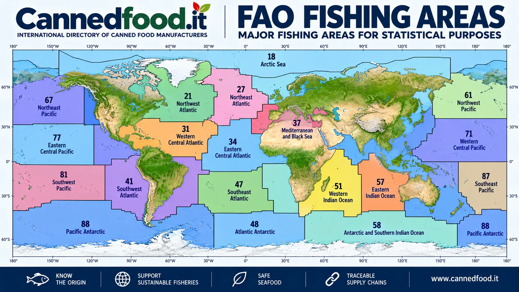
Illustrative world overview of FAO major marine fishing areas, branded Cannedfood.it
Illustrative overview only. The image is not an authoritative boundary map and must not be used to determine exact FAO area limits. For geographic boundaries, consult the official FAO mapping resources linked below.
Important distinction: A FAO area number describes a statistical fishing region, not a seafood safety rating, environmental score or sustainability certificate.

What are FAO fishing areas?

The Food and Agriculture Organization of the United Nations (FAO) divides the world's fisheries into major statistical areas. These geographical divisions support the collection, reporting and comparison of fisheries data.

There are 19 major marine fishing areas, as well as separate major areas for inland waters. An area may encompass many different fisheries, species, fleets and management arrangements; conditions can vary substantially within a single FAO area.

FAO codes commonly appear in seafood documentation and may be included in consumer-facing information, depending on the product and applicable labeling rules.

The 19 major FAO marine fishing areas

The following codes identify the major marine statistical areas. Their names are presented in English for international trade reference.

Major marine fishing areas for statistical purposes
FAO codeOfficial area name
18Arctic Sea
21Atlantic, Northwest
27Atlantic, Northeast
31Atlantic, Western Central
34Atlantic, Eastern Central
37Mediterranean and Black Sea
41Atlantic, Southwest
47Atlantic, Southeast
48Atlantic, Antarctic
51Indian Ocean, Western
57Indian Ocean, Eastern
58Indian Ocean, Antarctic and Southern
61Pacific, Northwest
67Pacific, Northeast
71Pacific, Western Central
77Pacific, Eastern Central
81Pacific, Southwest
87Pacific, Southeast
88Pacific, Antarctic

For detailed boundaries and subareas, use FAO's official geographic references rather than relying on this summary table or an illustrative image.

FAO areas and seafood traceability

FAO area information can help buyers understand the broad origin of wild-caught seafood, including fish intended for canning. However, meaningful traceability normally requires more than a single area code.

  • Species identification: scientific and commercial names, where applicable.
  • Catch location: FAO area and, where available, more precise fishing grounds.
  • Fishing method: gear type and relevant fishery information.
  • Supply-chain records: vessel or fleet information, landing records, processing lots and supplier documentation, as appropriate.
  • Compliance: documentation relevant to applicable fisheries and food laws.

Requirements differ by country, product category and whether the seafood is wild-caught or farmed. A FAO fishing area is not the same as a country of origin or a processing location.

Does a FAO area indicate sustainable fishing?

No. Sustainability is assessed at the level of a specific fishery, stock and management system, not simply by a broad ocean region. Different species and fishing practices within the same FAO area may have very different environmental impacts.

Responsible purchasing decisions can consider stock assessments, fisheries management, bycatch, habitat impacts, independent certification where relevant, and the quality of the supplier's traceability records.

For example, a statement such as “Caught in FAO Area 27” identifies a broad geographical area in the Northeast Atlantic; it does not, by itself, establish that a particular tuna, sardine or mackerel product comes from a sustainable fishery.

Do FAO fishing areas guarantee seafood safety?

No. Food safety depends on factors such as species, potential contaminants, hygienic handling, temperature control, processing and compliance with applicable food-safety standards.

For canned seafood, safe manufacturing and appropriate controls remain essential. A geographical fishing-area code cannot replace laboratory testing, hazard analysis, regulatory compliance or product-specific quality assurance.

Practical questions for seafood importers and buyers

  1. What is the fish species and its scientific name?
  2. In which FAO fishing area, and more precisely where, was it caught?
  3. Which fishing method was used?
  4. What traceability and legal-catch documentation is available?
  5. What evidence supports any sustainability claims?
  6. Which food-safety controls and certifications apply to the processed product?

These questions are especially relevant when sourcing canned tuna, sardines, mackerel and other preserved seafood for international markets.

Official references and further reading

For authoritative boundaries, definitions and updates, consult the organizations responsible for fisheries statistics and seafood regulation:

Editorial note: This guide provides general information. Fishing-area definitions, seafood labeling obligations and fisheries status should be checked against current official sources before commercial or regulatory use.

😥 Any bug here? ❗ Any mistake in this page?
Please inform us by email or WhatsApp. Thank you.